
Results for "total station"

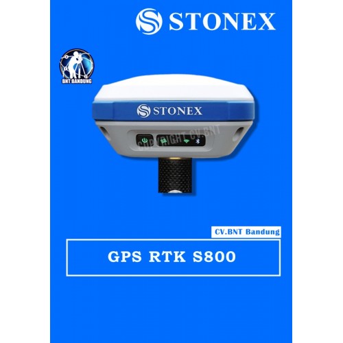
GPS Geodetik RTK GNSS Stonex S800

GPS Stonex S800 mampu melakukan pelacakan melalui berbagai macam GNSS seperti GPS, GLONASS, Galileo, BeiDou, IRNSS, dan QZSS dengan dukungan 555 channels. Melalui keunggulan pelacakan menggunakan berbagai GNSS lah yang menjadikan GPS S800 mampu memberikan hasil kinerja yang sangat akurat. Designnya sendiri dibuat praktis dengan dilapisi IP67 yang mampu menahan debu, air dan goncangan sekalipun. Pastinya GPS S800 sangatlah kuat dan kukuh jika dibawa ke medan yang cukup kasar, sangat recommended.

Dengan teknologi canggih E-Bubble, GPS S800 dapat langsung menampilkan tiang vertikal dan titik yang terekam otomatis pada perangkat lunaknya saat tiang diratakan. Hal ini memungkinkan untuk menghitung titik dalam kemiringan >30 dereajat. GPS S800 pun memiliki teknologi canggih lainnya seperti radio internal 10-470MHz dan 902,4-928MHz, modem gsm 4G dengan internet yang sangat cepat dan juga Wi-Fi yang akan membantu para surveyor dalam mengunduh dan mentransfer data dari / ke hp, tablet, laptop dan komputer. Kapasitas dan daya tahan baterai yang diberikan pun terbilang cukup lama untuk menemani surveyor dalam kegiatan surveying seharian, yaitu 5200mAh yang mampu bertahan selama 10 jam. Surveyor tidak perlu khawatir, karena baterai ini sifatnya rechargeable alias dapat diisi ulang yang hanya memakan waktu 4 jam.

SPESIFIKASI GPS STONEX S800:

  • Channels: 555
  • GPS: L1C/A, L1C, L2P, L2C, L5
  • GLONASS: L1C/A, L2C, L2P, L3, L5
  • BeiDou: B1, B2, B3
  • Galileo: E1, E5 AltBOC, E5a, E5b, E6
  • QZSS: L1C/A, L1C, L2C, L5, L6
  • SBAS: L1, L5
  • IRNSS: L5
  • Position Rate: 5 Hz, optional up to 20 Hz
  • Signal Reacquisition: < 1 sec
  • RTK Signal Initialization: Typically < 10 s
  • Hot Start: Typically < 15 s
  • Initialization Reliability: > 99.9 %
  • Internal Memory: 8 GB
  • Battery: Rechargeable 7.2 V-6800 mAh
  • Rechargeable 7.2 V-5200 mAh
  • Voltage: 9 to 18 V DC external power input with over-voltage protection (5 pins Lemo)
  • Working Time: 10 hours
  • Charge Time: Typically 4 hours
  • Weight: 1.2 Kg
  • Dimensions: 146 mm x 146 mm x 76 mm
  • Operating Temperature: -40 °C to 65 °C
  • Storage Temperature: -40 °C to 80 °C
  • Waterproof/Dustproof: IP67
  • Shock Resistance: Designed to endure to a 2m drop pole on concrete floor with no damage
  • Vibration: Vibration resistant


Note:
*Harga Dapat Berubah Sewaktu – waktu tanpa pemberitahuan terlebih dahulu.
*Mohon tanya ketersediaan barang terlebih dahulu.
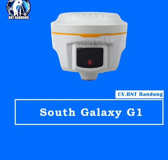
Spesifikasi South Galaxy G1

GNSS performance

  • Channels: 220(standard), 965(optional), 555(optional)
  • GPS: L1C/A, L1C, L2E, L2C, L5
  • GLONASS: L1C/A, L1P, L2C/A, L2P, L3
  • BDS: B1, B2, B3 (only with installing SOUTH and NovAtel board)
  • GALILEO: E1, E5a, E5b, Alt-BOC, E6
  • SBAS: L1 C/A, L5 | QZSS, WAAS, MSAS, EGNOS, GAGAN
  • L-Band: —
  • Positioning output rate: 1Hz, 2Hz, 5Hz, 10Hz, 20Hz & 50Hz (depends on installed option)
  • Initialization time: <10s
  • Initialization reliability: >99.99%

Positioning precision

  • Static surveying:
    • Horizontal: 2.5mm+0.5ppm;
    • Vertical: 5mm+0.5ppm
  • Code differential positioning:
    • Horizontal: 25cm+1ppm;
    • Vertical: 50cm+1ppm
  • Real-time kinematic surveying:
    • Horizontal: 8mm+1ppm;
    • Vertical: 15mm+1ppm
  • RTX: —
  • SBAS positioning: Typically<5m 3DRMS

User interaction

  • Operaing system: Linux
  • Buttons: Single button operation
  • LCD: —
  • Indicators: 3 indicate lights
  • Web UI: Freely to configure and monitor the receiver by accessing to the web server via Wi-Fi and USB

Hardware performance

  • Dimension: 129mm (Diameter) x 112mm (Height)
  • Weight: 1kg (battery included)
  • Material: Magnesium aluminum alloy shell
  • Operating temperature: -45°C ~ +60°C
  • Storag temperature: -55°C ~ +85°C
  • Humidity: 100% Non-condensing
  • Waterproof/Dustproof: IP68 standard,
  • Shock and vibration: Withstand 2 meters drop onto the cement
  • Power Supply: 9-25V DC
  • Battery: Lithium-ion battery, 7.4V 3400mAh/per
  • Battery: 4 standard batteries (optional)

Communications

  • I/O port: 5-PIN LEMO port, 7-PIN USB port (with OTG)
  • Wireless modem: Built-in radio, 1W/2W/3W switchable, typically work range can be 8KM
  • Frequency Range: 410-470MHz
  • Communication Protocol: TrimTalk, SOUTH
  • Cellular Mobile Network: TDD-LTE/FDD-LTE 4G network modem
  • Bluetooth: BLEBluetooth 4.0 standard

WIFI

  • Standard: 802.11 b/g standard
  • WIFI Hotspot

Purchase Package:

  • South Galaxy G1
  • Base
  • Rover
  • Controller
  • Farlink Radio 12 km
  • Garansi Resmi, DKI Jakarta Gratis Pelatihan


Note:
*Harga Dapat Berubah Sewaktu – waktu tanpa pemberitahuan terlebih dahulu.
*Mohon tanya ketersediaan barang terlebih dahulu.

Fitur Hi-Target V60

Smart Operation:

  • Visual LED screen and voice assistance guide your field operation quickly
  • Multi one-button operations. Auto base setup by one button without controller
  • Standard Rinex data and HI-TARGET raw data recorded at the same time
  • Quick upgrade by USB

Multi-constellation Tracking:

  • 220 tracking channels
  • Supports GPS, GLONASS, GALILEO, BDS, SBAS
  • NGS approved GNSS antenna

Optional Transceiver UHF Radio:

  • The transceiver UHF radio enables the working mode to be switchable between base and rover
  • 2-watt HI-TARGET internal UHF radio and 1-watt Satel internal UHF radio are optional.Satel internal UHF radio is compatible with other radios.

Seamlessly Operation in CORS System:

  • Built-in cellular makes V60 work perfectly with network RTK positioning

Powerful Battery:

  • Powered by high-capacity (5000mAh) Li-ion battery to insure whole day operation

Rugged Design, IP67:

  • IP67 dust/water protection
  • Withstands 3-meter natural fall onto concrete

Spesifikasi HI-Target V60

Measurements

  • 220 Channels/Saluran
  • High precision multiple correlator for GNSS pseudo range measurements.
  • Unfiltered, unsmoothed pseudo range measurements data for low noise, low multipath error, low time domain correlation and high dynamic response.
  • Very low noise GNSS carrier phase measurements with <1 mm precision in a 1 Hz badwidth.
  • Signal to noise ratios reported in dB-Hz

Satellite Signals Tracked Simultaneously

  • GPS ………………………….. Simultaneous L1C/A, L2C, L2E, L5
  • GLONASS …………………. Simultaneous L1C/A, L1P, L2C/A, (GLONASS M only), L2P
  • SBAS ………………………… Simultaneous L1 C/A, L5 (EGNOS, WAAS, MSAS, GAGAN, QZSS)
  • Galileo ……………………… Simultaneous L1 BOC, E5A, E5B, E5AltBOC (Optional)
  • BDS …………………………. B1, B2

Positioning Performance

  • Hot Start …………………. Typically <10s
  • Cold Start ………………… Typically <15s

High-precision static

  • Horizontal ……………… 2.5 mm + 0.1 ppm RMS
  • Vertical ………………….. 3.5 mm + 0.4 ppm RMS

Static and Fast Static

  • Horizontal ……………… 2.5 mm + 0.5 ppm RMS
  • Vertical ………………….. 3.5 mm + 0.5 ppm RMS

Post Processing Kinematic (PPK / Stop & Go)

  • Horizontal …………………. 8mm+1ppm RMS
  • Vertical ……………………… 15mm+1ppm RMS
  • Initialization time  ……… Typically 10 minutes for base while 5 minutes for rover
  • Initialization reliability .. Typically > 99.9%

Real Time Kinematic (RTK) Surveying

  • Horizontal …………………. 8mm+1ppm RMS
  • Vertical ……………………… 15mm+1ppm RMS
  • Initialization time ………. Typically 2-10s
  • Initialization reliability .. Typically > 99.9%

GPS RTK GNSS Sokkia GRX3

Deskripsi  dan Spesifikasi :

  •  Receiver GNSS GRX3 – Fleksibilitas Luar Biasa dalam desain yang ringkas
  •  Sokkia GRX3 lebih kecil, lebih ringan, dan dikemas dengan teknologi GNSS paling canggih dalam desain yang dibangun untuk tahan terhadap lingkungan lapangan yang paling keras.
  •  Semua sinyal, semua satelit dan semua rasi bintang – dalam desain yang ringkas dan kokoh, dengan IMU dan eCompass yang terintegrasi.
  •  Teknologi Tilt Sokkia : Menggabungkan unit pengukuran inersia 9-sumbu revolusioner (IMU) dan eCompass ultra-kompak, yang mengkompensasi kesalahan level hingga 15 derajat.

Fitur:

  •  Teknologi Sokkia Tilt
  •  Teknologi L Band Ready
  •  226 Saluran Pelacakan Universal (GPS, GLONASS, Galileo, BeiDou, IRNSS, QZSS, SBAS)
  •  Radio UHF dan SiteCom ™ 400 MHz yang terintegrasi
  •  Teknologi Fusion Positioning ™
  •  Jumlah Saluran Pelacakan Universal: teknologi 226 UTC
  •  Sinyal yang Dilacak: GPS L1 C / A, L1C, L2P (Y), L2C, L5, GLONASS L1 C / A, L1P, L2 C / A, L2P, L3C, BeiDou B1, B2, Galileo E1, E5a, E5b, Alt-BOC, SBAS L1 C / A, L5 WAAS / MSAS / EGNOS / GAGAN, QZSS L1 C / A, L1C, L1-SAIF, L2C, L5
  •  Statis / Statis Cepat: H: 3 mm + 0,4 ppm V: 5 mm + 0,5 ppm *
  •  Memori: Internal Non-removable 8 GB
  •  Radio: Radio UHF 425-470 MHz bawaan
  •  Perlindungan Debu / Air: IP67
  •  Dimensi: 150 x 100 x 150 mm (w x h x d)
  •  Waktu Pengoperasian: Mode RX -10hr, Mode TX 1W – 6hr

Kelengkapan

  • 2x ( Base & Rover )KIT, GRX3 425‐470 UHF w/4G CELL INTL OAF+, 226 CH, ALL SIG 10Hz RADIO+LL RTK
  • 2x Antenna UHF 450-470 Male BNC Hiper XT
  • 2x Sokkia GRX3 Carrying Case 1x Magnet Field Software
  • 1x Controller SHC500
  • 1x Bracket
  • 1x Magnet Office Tools + Post Processing
  • 1x Prism Spacer, 100mm
  • 1x BKT, GPS Antenna Height Measure
  • 1x Tribrach
  • 1x Tripod
  • 1x Litepole

Note:

  • Harga Dapat Berubah Sewaktu-waktu tanpa pemberitahuan terlebih dahulu.
  • Mohon tanya ketersediaan barang terlebih dahulu.

Auto level Waterpass Sokkia B40A

SPESIFIKASI

  • Pembesaran 24x
  • Lingkaran Diameter 32mm
  • Akurasi 2.0mm
  • Tingkat Edaran 10 ‘ / 2mm
  • Jarak Minimum 0, 2 meter
  • Stadia Rasio 1: 100
  • Dimensi 130x215x135 mm

SUDAH TERMASUK AKSESORIS KOMPLIT STANDAR

  • 1x RAMBU UKUR 3 METER
  • 1x TRIPOD/STATIF
  • Manual Book Bahasa Indonesia

&lt;strong&g

t;Note:
*Harga Dapat Berubah Sewaktu – waktu tanpa pemberitahuan terlebih dahulu.
*Mohon tanya ketersediaan barang terlebih dahulu.