
Results for "hi target"

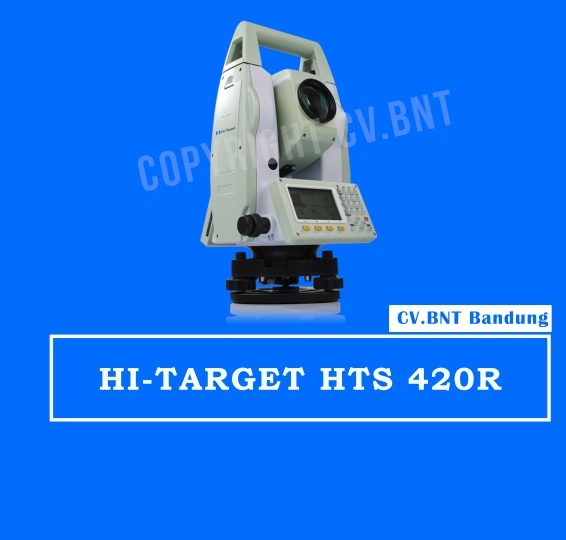
HI-TARGET HTS 420R

  • Angle Measurement
    Measurement Method: Absolute Encoding
    Minimum Readout: 1″/5″/10″(0.3mgon/1.5mgon/3mgon)optional
    Accuracy : 2”
  • Distance Measurement (with Reflector)
    Single Prism: 3000m (9,842ft.) under good condition3
    Three Prisms: 6000m (19,685ft.) under good condition3
    Reflective Sheet: 800m (2,624 ft.)
    Accuracy: 2 mm +2ppm
    Measuring Time (Fine/Quick/Tracking): 1.5s/1s/ 0.5s
  • Distance Measurement (Reflectorless)
    Reflectorless2 Range: 350m
    Single Prism: >7500m (24606ft.)
    Accuracy: 3mm+2ppm
    Measuring Time: 1.5s
  • Telescope
    Magnification: 30X
    Field of View: 1°30′ (2.7m at 100m)
    Minimum Focusing Distance: 1.2m
    Reticle: Illuminated
  • Compensator
    System: Dual-axis (optional)
    Working Range: ±3′
    Setting Accuracy: 1″
    Communication
  • Bluetooth
    Interface: Standard RS232, SD card4, USB pen drive, mini-USB
    Internal Data Memory: Approx. 20,000 Points
    Data Format: ASCII
  • Operation
    Operation system: Real-time Operating System
    Display: High resolution backlight black and white display with contrast adjustment/ Graphics: 280 x 160 pixels / Character: 6 lines x 25 characters
    Keyboard: 2 sides Alphanumeric backlit crystal keyboard
  • Laser Plummet
    Type: Laser point, 4 brightness levels adjustment / Optical plummet (optional)
    Centering Accuracy: 1 mm at 1.5m instrument height
  • Power Supply
    Battery Type: Rechargeable Li-ion battery
    Voltage/Capacity: ZBA-400: 7.4V (DC) / 3000mAh
    Operating Time With ZBA-400: Optimal 16 hours5 (Continuous angle measurement every 30 seconds) / 10 hours (typical)
    Measuring Times: Approx. 12000 times
  • Environmental
    Operating Temperature: -20℃ ~﹢50℃( -4℉ to +122℉)
    Storage Temperature: -40℃ ~﹢70℃(-40℉ to + 158℉)
    Dust&Water Proof (IEC60529 Standard)/Humidity: IP54, 95%, non-condensing


SUDAH TERMASUK AKSESORIS KOMPLIT STANDAR
1x PRISMA AK
1x PRISMA ADS
1x POLE
2x TRIPOD

Note:
*Harga Dapat Berubah Sewaktu – waktu tanpa pemberitahuan terlebih dahulu.
*Mohon tanya ketersediaan barang terlebih dahulu.
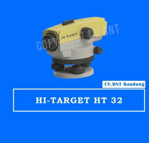
HI- TARGET HT-32

Standard Deviation for 1km double levelling: 1.0 mm

Telescope

  • Magnification: 32x
  • Field of View: 1°20′
  • Objective Aperture: 38mm
  • Minimum Focusing Distance: 1m
  • Stadia: 100

Compensator

  • Type: X-style Air Dumping
  • Compensating Range: ±15′
  • Setting Accuracy: ±0.5″

Environmental Conditions

  • Operating Temperature: -20°C ~ +50°C
  • Storage Temperature: -40°C ~ +70°C
  • Protection Level: IP66
  • Net Weight: 1.4KG

SUDAH TERMASUK AKSESORIS KOMPLIT STANDAR

  • 1x RAMBU UKUR 3 METER
  • 1x TRIPOD/STATIF

Note:
*Harga Dapat Berubah Sewaktu – waktu tanpa pemberitahuan terlebih dahulu.
*Mohon tanya ketersediaan barang terlebih dahulu.

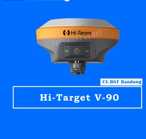
GPS RTK HI-TARGET V90

Fitur :

  • Kecil dan ringan
  • Beratnya hanya 950g.
  • Ukuran Diameter 153mm x Tinggi 83mm.

Pelacakan Multi-konstelasi GPS Geodetik RTK

  • 220 saluran pelacakan
  • Mendukung GPS, GLONASS, GALILEO, BDS, SBAS
  • NGS menyetujui antena GNSS pita penuh

Aplikasi Cerdas

  • Menawarkan survei kemiringan dengan sudut kemiringan maksimum 30 derajat.
  • Mendukung kalibrasi gelembung elektronik
  • Modul NFC internal membuat komunikasi Bluetooth cepat dan mudah.
  • Bantuan suara yang cerdas memandu operasi lapangan. Suara bisa DIY.
  • Data Rinex standar dan data mentah HI-TARGET direkam secara bersamaan.

Radio UHF Transceiver Opsional

  • Radio UHF transceiver memungkinkan mode kerja yang dapat dialihkan antara basis dan penjelajah.
  • Tiga jenis radio UHF internal menyediakan frekuensi yang berbeda berdasarkan kebutuhan pengguna. Radio UHF internal Pacific Crest TrimTalk © kompatibel dengan radio lain.

Koneksi Multi Jaringan

  • Mendukung GPRS, GSM dan WCDMA
  • Mendukung WIFI

Baterai yang Kuat

  • Didukung oleh baterai Li-ion berkapasitas tinggi (5000mAh) untuk memastikan pengoperasian sehari penuh

Desain Kasar

  • IP67 tahan debu dan tahan air
  • Mampu bertahan saat jatuh 3 meter secara alami ke beton


POSITIONING KINERJA

Statik dan Statik Cepat GNSS Survei

  • Horisontal …………………… 2.5mm + 0.5ppm RMS
  • Vertikal…………………………. 5mm + 0.5ppm RMS
  • Post Processing kinematik (PPK / Stop & Go) GNSS Survei
  • Horisontal ……………………… .. 1cm + 1ppm RMS
  • Vertikal ………………………… 2,5 cm + 1ppm RMS
  • Waktu inisialisasi ……… .Typically 10 menit untuk basis sementara 5 menit untuk rover
  • Kehandalan inisialisasi …… Biasanya> 99,9

Real Time Kinematik (RTK) Survei

Base Absolute

  • Horisontal ……………………… .. 8mm + 1ppm RMS
  • Vertikal…………………………. 15mm + 1ppm RMS
  • Jaringan RTK
  • Horisontal ……………………… .. 8mm + 0.5ppm RMS
  • Vertikal ………………………… .. 15mm + 0.5ppm RMS
  • Waktu inisialisasi …… .. … Biasanya <8 detik
  • Kehandalan inisialisasi …… .Typically> 99,9%
  • Positioning kode Differential GNSS
  • Horisontal………………………. 25cm + 1ppm RMS
  • Vertikal …………………………… 50cm + 1ppm RMS
  • SBAS ……… 0.50m Horizontal, Vertikal 0.85m

HI-TARGET Internal UHF Radio (Standard)

  • Frekuensi … 450 ~ 470MHz dengan 116 saluran
  • Daya transmisi … 0.5W, 1W, 2W disesuaikan
  • Kecepatan transmisi ……… .9.6Kbps, 19.2Kbps
  • jarak antara base dan rover ………… 0,3 ~ 5km khas, 8 ~ 10kmoptimal
  • Pacific Crest XDL Micro internal UHF Radio
  • Frekuensi …………………………… 0,403 ~ 473MHz
  • Transmisi daya ……………… 0.5W, 2W disesuaikan
  • Transmisi kecepatan …………….. Sampai 19.2Kbps
  • Mendukung sebagian besar protokol komunikasi radio
  • jarak antara base dan rover ……………………… 3 ~ 5 kilometer khas, 8 ~ 10km optim

HI-TARGET Internal UHF Radio (Standard)

  • Frekuensi … 450 ~ 470MHz dengan 116 saluran
  • Daya transmisi … 0.5W, 1W, 2W disesuaikan
  • Kecepatan transmisi ……… .9.6Kbps, 19.2Kbps
  • jarak antara base dan rover ………… 0,3 ~ 5km khas, 8 ~ 10kmoptimal
  • Pacific Crest XDL Micro internal UHF Radio
  • Frekuensi …………………………… 0,403 ~ 473MHz
  • Transmisi daya ……………… 0.5W, 2W disesuaikan
  • Transmisi kecepatan …………….. Sampai 19.2Kbps
  • Mendukung sebagian besar protokol komunikasi radio
  • jarak antara base dan rover ……………………… 3 ~ 5 kilometer khas, 8 ~ 10km optim

SISTEM KONFIGURASI

Sistem

  • Penyimpanan data 16GB internal storage (Mendukung hingga 32GB SD card eksternal)
  • Rekam GNS dan Format RINEX secara bersamaan


Data Format

  • Output posisi 1HZ, hingga 20Hz
  • CMR : CMR, CMR +, sCMRx input dan output
  • RTCM : RTCM 2.1, 2.3, 3.0, 3.1, 3.2 input dan output
  • Navigasi output ASCII : NMEA-0183 GSV, AVR, RMC, HDT, VGK, VHD, ROT, GGK, GGA, GSA, ZDA, VTG, GST, PJT, PJK, BPQ, GLL, GRS, GBS
  • Navigasi output biner : GSOF

Note:
*Harga Dapat Berubah Sewaktu – waktu tanpa pemberitahuan terlebih dahulu.
*Mohon tanya ketersediaan barang terlebih dahulu.

GPS RTK HI-Target V30

Deskripsi Hi Target V30 GNSS RTK GPS Geodetik / Hi-Target V 30 / HiTarget V-30
The V30 GNSS RTK system is designed to meet high quality standards at an affordable price. It is outstanding in its class, with a rugged design and user-friendly functions.

KEY FEATURES:

  1. BD970 GNSS engine
  2. Support GPS, GLONASS, BDS, GALILEO
  3. Rugged design and user-friendly functions

DETAIL ADVANTEAGE FUNCTIONS:

Multi-constellation tracking

  • 220 tracking channels
  • Supports GPS, GLONASS, BDS, SBAS
  • NGS approved GNSS antenna

Intelligent operation

  • Equipped with a smart speaker guiding the whole operation
  • Multi one-button functions make fieldwork easier, such as auto base setup by one button, the rover can get fix solution once it is turned on

Diversify RTK application

  • Optional transceiver UHF radio
  • The transceiver UHF radio enables the working mode to be switchable between base and rover
  •  Removable internal UHF radio enables users to fix or exchange simply
  • Seamless operation in CORS system
  • Built-in GPRS/GSM/3G module ensures that the V30 works perfectly with network RTK positioning

Long-life battery

  • Powered by 5000mAh Li-ion battery
  • Static working time 13 – 15 hours
  • RTK Rover (UHF/GPRS/GSM) working time 10 – 12 hours
  • RTK Base working time 8 – 10 hours

Rugged and unique design

  • IP67 dust/water protection
  • Withstands 3-meter natural fall onto concrete
  • Rapid tracking and perfect avoidance or reduction of obstruction and multipath effect to ensure superior positioning capability.


Note:
*Harga Dapat Berubah Sewaktu – waktu tanpa pemberitahuan terlebih dahulu.
*Mohon tanya ketersediaan barang terlebih dahulu.


Fitur Hi-Target V60

Smart Operation:

  • Visual LED screen and voice assistance guide your field operation quickly
  • Multi one-button operations. Auto base setup by one button without controller
  • Standard Rinex data and HI-TARGET raw data recorded at the same time
  • Quick upgrade by USB

Multi-constellation Tracking:

  • 220 tracking channels
  • Supports GPS, GLONASS, GALILEO, BDS, SBAS
  • NGS approved GNSS antenna

Optional Transceiver UHF Radio:

  • The transceiver UHF radio enables the working mode to be switchable between base and rover
  • 2-watt HI-TARGET internal UHF radio and 1-watt Satel internal UHF radio are optional.Satel internal UHF radio is compatible with other radios.

Seamlessly Operation in CORS System:

  • Built-in cellular makes V60 work perfectly with network RTK positioning

Powerful Battery:

  • Powered by high-capacity (5000mAh) Li-ion battery to insure whole day operation

Rugged Design, IP67:

  • IP67 dust/water protection
  • Withstands 3-meter natural fall onto concrete

Spesifikasi HI-Target V60

Measurements

  • 220 Channels/Saluran
  • High precision multiple correlator for GNSS pseudo range measurements.
  • Unfiltered, unsmoothed pseudo range measurements data for low noise, low multipath error, low time domain correlation and high dynamic response.
  • Very low noise GNSS carrier phase measurements with <1 mm precision in a 1 Hz badwidth.
  • Signal to noise ratios reported in dB-Hz

Satellite Signals Tracked Simultaneously

  • GPS ………………………….. Simultaneous L1C/A, L2C, L2E, L5
  • GLONASS …………………. Simultaneous L1C/A, L1P, L2C/A, (GLONASS M only), L2P
  • SBAS ………………………… Simultaneous L1 C/A, L5 (EGNOS, WAAS, MSAS, GAGAN, QZSS)
  • Galileo ……………………… Simultaneous L1 BOC, E5A, E5B, E5AltBOC (Optional)
  • BDS …………………………. B1, B2

Positioning Performance

  • Hot Start …………………. Typically <10s
  • Cold Start ………………… Typically <15s

High-precision static

  • Horizontal ……………… 2.5 mm + 0.1 ppm RMS
  • Vertical ………………….. 3.5 mm + 0.4 ppm RMS

Static and Fast Static

  • Horizontal ……………… 2.5 mm + 0.5 ppm RMS
  • Vertical ………………….. 3.5 mm + 0.5 ppm RMS

Post Processing Kinematic (PPK / Stop & Go)

  • Horizontal …………………. 8mm+1ppm RMS
  • Vertical ……………………… 15mm+1ppm RMS
  • Initialization time  ……… Typically 10 minutes for base while 5 minutes for rover
  • Initialization reliability .. Typically > 99.9%

Real Time Kinematic (RTK) Surveying

  • Horizontal …………………. 8mm+1ppm RMS
  • Vertical ……………………… 15mm+1ppm RMS
  • Initialization time ………. Typically 2-10s
  • Initialization reliability .. Typically > 99.9%

Waterpass Auto Level Topcon ATB4A Made in China

  1. Akurasi Tinggi – Dengan ketelitian hingga ±2.0 mm per 1 km double run, alat ini sangat cocok untuk proyek skala besar.

  2. Desain Tahan Lama – Dilengkapi proteksi IPX6, tahan terhadap air dan debu, sehingga bisa digunakan di berbagai kondisi lapangan.

  3. Optik Berkualitas – Lensa terang dan jernih memberikan visibilitas lebih baik meski di cahaya rendah.

  4. Operasional Praktis – Mekanisme auto leveling membuat penggunaannya lebih cepat dan efisien.

  5. Harga Lebih Terjangkau – Dibandingkan produk Jepang asli, versi Made in China memberikan solusi hemat tanpa mengurangi fungsi utama.

Spesifikasi Teknis Topcon ATB4A Made in China

  • Perbesaran Teropong: 24x

  • Akurasi: ±2.0 mm (1 km double run)

  • Sudut Bidik: 360°

  • Fokus Minimum: 0.3 m

  • Proteksi: IPX6 (tahan air & debu)

  • Berat: Ringan, mudah dibawa ke lokasi proyek

Aplikasi Waterpass Auto Level Topcon ATB4A

Alat ini sering digunakan dalam:

  • Konstruksi bangunan dan jalan raya

  • Pekerjaan infrastruktur seperti jembatan, saluran air, dan drainase

  • Pemetaan topografi sederhana

  • Pekerjaan instalasi pipa dan proyek sipil lainnya

BELUM TERMASUK AKSESORIS KOMPLIT STANDAR


Kesimpulan

Waterpass Auto Level Topcon ATB4A Made in China merupakan pilihan tepat bagi Anda yang membutuhkan alat ukur presisi dengan harga lebih hemat. Dengan kombinasi akurasi tinggi, ketahanan lapangan, dan kemudahan penggunaan, alat ini siap mendukung kelancaran pekerjaan survei maupun konstruksi.

Untuk informasi lebih lanjut, pembelian, maupun sewa alat survey seperti Total Station, Theodolite, GPS Geodetik, Drone Mapping, dan Waterpass Auto Level, silakan hubungi CV. BNT di WhatsApp/Telepon 0812-2222-9059 atau kunjungi website resmi 👉 www.totalstation.co.id.